Welcome to the Serra de Tramuntana in 2015
The Serra de Tramuntana has been declared a World Heritage Site by UNESCO under the Cultural Landscape category. This is the international community’s acknowledgement of the near-perfect symbiosis between the action of human beings and nature, which has occurred for centuries, resulting in a monumental work by humans in which culture, traditions, aesthetics, spirituality and identity are merged.
The cultural landscape of the Serra is the fruit of the exchange of knowledge between cultures, with small-scale works performed collectively for a productive end, conditioned by the limitations imposed by the physical medium. Limitations overcome by knowledge and the intelligent use of resources, without destroying the medium. And it is also the recreation of a region through the collective imagination and works by artists who have found inspiration in it.
According to the European Landscape Convention, Cultural Landscape is “an area, as perceived by people, whose character is the result of the action and reaction of natural and/or human factors”. This would suggest that the aim is not only to maintain the Serra as it is now. It is also to improve human intervention, promoting it with sustainable activities in accordance with certain objectives.
These are the lines along which the Serra de Tramuntana Management Plan has been working, taking the economic and social environment into account at all times. This is a strategic plan for the future which will bear fruit if it achieves the maximum involvement of all sectors, public and private, economic and social agents. The main goals established include the following areas:
Communication and participation
Economic development
Education, training and research (*)
Heritage
Visitor management
(*) Word Heritage in Young Hands. To know cherish and act. An educational resource kit for teachers. Published in 2002 by the United Nations Educational, Scientific and Cultural Organization
Situation
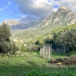
The Serra de Tramuntana mountain range forms the backbone of the north-west of Mallorca. It runs for around 90 km, with a maximum width of 15 km, over 18 municipalities, the largest of which are Calvià, Pollença and Escorca—, and covers 30% of the island’s territory and more than 1,000 km2. Approximately 8,000 people live in the central areas, but the buffer zone population is 40,000 inhabitants. Several of its peaks have an altitude of over 1000 m, and the highest are Puig Major (1,443 m), Puig de Massanella (1,348 m), Serra d’Alfàbia (1,069 m), Es Teix (1,064) and Galatzó (1,026 m).
Information courtesy of the Consell of Mallorca


