Route that runs between Sóller and Fornalutx. This route traverses the most famous villages of the valley of Sóller that are enveloped by beautiful spaces for growing oranges and olives. Text excursion: Jaume Deia
http://www.senderosdemallorca.com/
Contacts
Type of trip: Hiking
Location: North West of Mallorca
Nearest Town: Sóller – Fornalutx (Sóller)
Degree of difficulty: Low
Total distance: 7,810 km
Total duration: 4 hours and 30 minutes
Access: on the bus line Palma – Port de Sóller.
Starting point: Farmhouse des Comte
Circular route: If
Maximum altitude: 298 m
Recommended Season: All year

Itinerary
-
Comte des farmstead
Distance 0.000 km – Time 0 hours – Altitude 46 m – N39 46’5.459 “E2 43’29.938”Park your car on Avenida Juli Ramis and from there begin our journey on the path of Biniaraix that connects the village with the City of Sóller. At the start of the tour, on the right we see the Church of the Curia des Comte. -
Biniaraix
Distance 0.960 km – Time 20 minutes – Altitude 96 m – N39 46’16.021 “E2 44’6.241”This small village depends on the town of Sóller and is home to about 500 people, and has its origins in an ancient Muslim farmhouse. Most notable is its integrated harmoniously with the surrounding territory, giving it a special charm architecture. Located on a small hill, steep cobbled streets and old houses run serpenteándose between peasants and lords. This place has attracted many artists and painters who have filled their canvases and picture books Biniaraix -
Sinks Biniaraix
Distance 1.050 km – Time 25 minutes – Altitude 103 m – N39 46’17.220 “E2 44’10.201”One of the ethnological elements must Biniaraix are your old washing. These are famous, because from them Biniaraix Canyon tour starts. We must follow the paved road that passes over these and addresses Marroig area -
The terraces of olive trees of Marroig
Distance 2,260 km – Time 1 hour and 25 minutes – Altitude 237 m – N39 46’32.339 “E2 44’37.201”The Marroig is located on the slopes of the Sierra de Son Torrella. This place is known for its beautiful and impressive terraces for olive cultivation -
Crossroad
Distance 3,000 km – Time 1 hour and 40 minutes – Altitude 298 m – N39 46’49.379 “E2 44’51.061”At this point we find a dirt road that is closed by a chain. We leave the paved road and follow this track. At the end of this go down the old road that connected the Marroig with Fornalutx -
Can Xoroi Museum
Distance 4.250 km – Time 2 hours and 20 minutes – Altitude 148 m – N39 46’57.961 “E2 44’30.839”Going to the town we will find the Museum can Xoroi which, inside, contains a large collection of painted tiles typical of Fornalutx and an old oil mill. This open on Friday and Saturday mornings, entry is free -
Fornalutx
Distance 4,420 km – Time 2 hours and 30 minutes – Altitude 152 m – N39 46’55.261 “E2 44’24.720”Fornalutx is the second town of Valle de Sóller. Its streets and houses make this village one of the most beautiful on the island. We can highlight some of the historic core assets as the thirteenth century church, the town hall tower seventeenth century and the Master’s house Can Xoroi. But one of the elements that nature has given to the people painted tiles are preserved in the cantilever roofs, whose tradition and origin dates back several centuries. To follow our journey we cross the town and head to the cemetery -
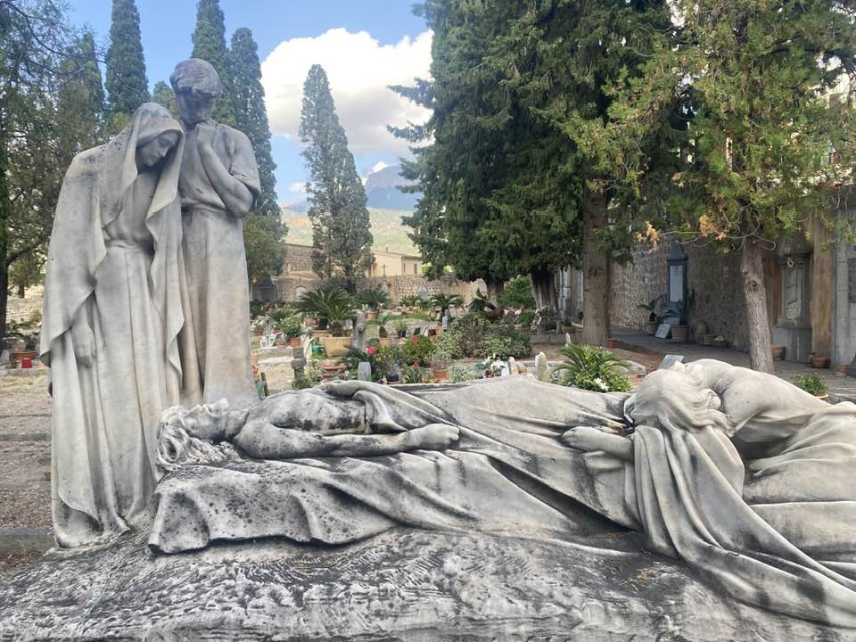
Cemetery Fornalutx
Distance 4,870 km – Time 2 hours and 55 minutes – Altitude 142 m – N39 46’44.940 “E2 44’11.641”The way forward passes the cemetery. This isolated the city center, creates an atmosphere of peace and quiet to the hiker -
Binibassí
Distance 5,730 km – Time 3 hours and 30 minutes – Altitude 102 m – N39 46’38.279 “E2 43’43.860”Binibassí, lower surface is formed by a small cluster of houses arranged around a beautiful Mallorcan possession. This core is located between the town of Sóller and Fornalutx. The element that stands out for its imposing architecture is the possession of Binibassí that, from afar, it looks like a great strength. The whole house was built in the sixteenth century in substitution to a senior.We highlight the portal, tower, harineo mill located next to the road, and the old laundry. This place was also an old farmstead as its name suggests “bini” “bassi” the house of the bassi -
Comte des farmstead
Distance 7,810 km – Time 4 hours and 30 minutes – Altitude 46 m – N39 46’6.359 “E2 43’26.580”
Other options
This route can be easily guided by a historian of Sóller to explain all the secrets of the points of cultural and historical interest group. For tours or groups, contact: info@mescultura.com or FaceBook.
Comments
Notes. WATERFALLS are a feature of routes Biniaraix to Fornalutx and the Fornalutx and Sóller on the second leg of the route. This is after the heavy rains of Autumn and winter – you might have to wade through water at some points.